Introduction

Why Anubis?

  • Data providers and network operators: a sudden receiver mal-functioning or any slow degradation may irreversibly affect collected GNSS observations and should be identified and fixed as soon as possible.
  • Data users: station and data selection using qualitative and quantitative control or environment indicators make user analysis more efficient.
  • G-Nut/Anubis is a free tool for basic post-processing functionalities, that supports both data provider and data user to satisfy their needs. Advanced versions additionally support monitoring of real-time data flow and include a variety of extra additional features.

Purposes

  • Daily(30s)/high-rate(>1Hz) observation files
  • Real-time (1Hz) data streams (real-time version)
  • Format and meta data checking/editing
  • Epoch-by-epoch code-based positioning using individual constellations
  • Receiver clock estimates, dilution of precision
  • Navigation data monitoring
  • Long-term monitoring (site instrumentation changes, hardware degradation)
  • Environment monitoring (obstructions, multipath, Co/N)

Features

Functionality

  • QC: metadata validation (header check)
  • QC: data quantitative check (algorithm-independent)
  • QC: data qualitative check (algorithm-dependent)
  • QC: single point positioning (a complex control)
  • ET: data/meta data translating/editing (advanced versions)

Operation

  • Thin mode: header metadata validation
  • Lite mode: quantitative data control
  • Full mode: qualitative/complex data control
  • Edit mode: meta data editing, data filtering (advanced versions)
  • RT mode: real-time operation (advanced versions)

Input

  • RINEX2/3 observation & navigation input data files
  • XML (file) and command-line configuration
  • SINEX for station metadata (advanced versions)
  • RTCM3 data streams (advanced versions)
  • SP3 precise orbits + RINEX clocks (future advanced versions)

Output

  • XTR file(s) with QC detailed metrics
  • XML file(s) with QC standard metrics
  • RINEX observation file(s) (advanced versions)
  • RINEX3/2 navigation file(s) (advanced versions)
  • JSON file(s) for QC plotting (future advanced versions)

Availability

Latest releases

  • Anubis Free: 2.3
  • Anubis Pro: 3.5
  • Anubis Real-Time: 3.5

Software version

  • Limited functionality (Free)
  • Full functionality (Pro)
  • Full+real-time (Real-Time)

Platforms

  • Linux (default distribution)
  • OS-X (extra fee)
  • Windows (extra fee)

Pre-compiled binaries and source code.

Download

Anubis Free

Free software for linux with basic functionality

no fee (for Linux)

Get free version

Anubis Pro

Commercial software with advanced functionality

from 1000 EUR

More information

Anubis Real-Time

Commercial software with advanced and real-time functionality

from 2500 EUR

More information

The price is for a major release, for a consecutive update the price is reduced by 50%.

Visualizations

Plot Anubis

A free perl tool (plot_anubis.pl) for making static plots from a single station QC file (Anubis's XTR output).

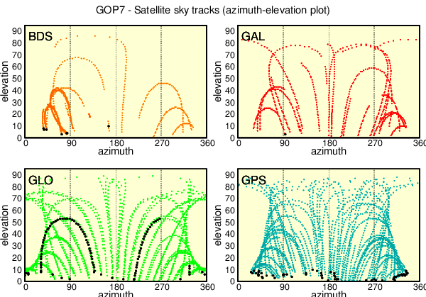
These plots include: general characteristics, availability of observations, number of observed satellites and signals, elevation-dependent distribution of observations, availability of code and phase bands, satellite visibility, code multipath and noise, signal-to-noise ratio, coordinate repeatability.

Download plot_Anubis.pl
The tool is provided without any support.


G-Nut's QC-charts

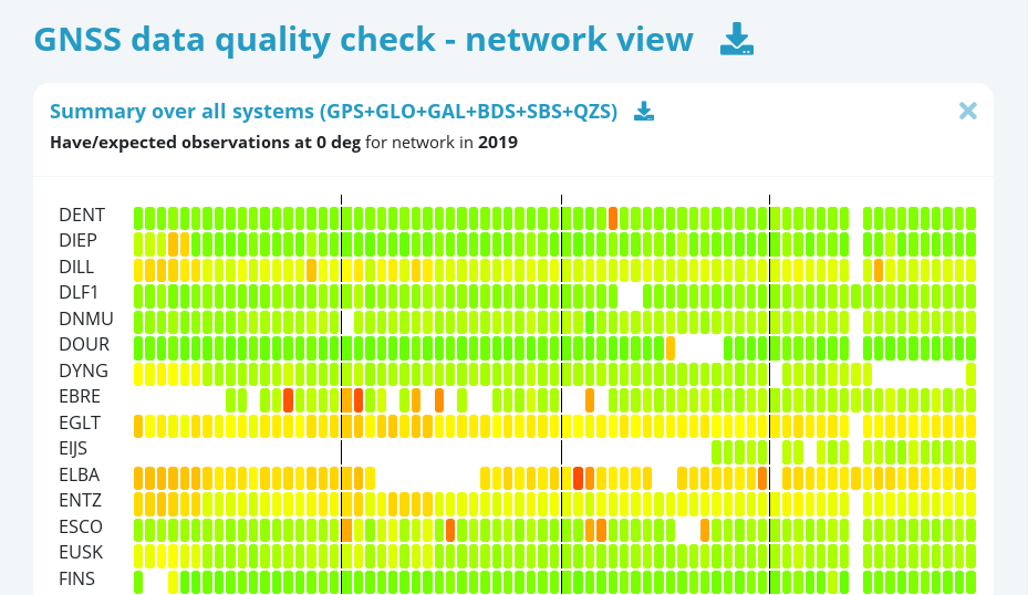
A complex system designed for a long-term monitoring of GNSS station network(s). It includes interactive visualizations of predefined QC key-parameters in two display modes: 1) network view, and 2) station view. The system can additionally provide alerts for predefined criterions and metadata views.

The system is driven by the PostgreSQL database engine, fed from the Anubis's QC-XML outputs, and it supports generating interactive web charts. It can be adapted to various other purposes, including monitoring of data from real-time streams.

For more information contact support@gnutsoftware.com.

Technology

Degraded quality of GNSS data observation represents an incorrigible error which should be identified as soon as possible. The Quality Control (QC) of the GNSS data is crucial for monitoring the performance of sensors, site environment and their changes in time. The knowledge of data quality and quantity is also useful prior data preservation, dissemination and utilization. The QC is eventually important for providing a feedback on data relevancy to the provider, and for providing a priori information for users interested in data analysis... (read more)